

Integrated data monitoring for smart and sensitive agriculture
India is the largest extractor of groundwater, and about 90% of which is used for irrigation. The efficiency of canal systems is such that the tail-ender villages do not receive adequate water. Multiple crops per year, increased demand for other users, urbanisation, have all led to increase in groundwater dependence, over the years. This has resulted in overexploitation of groundwater, water quality degradation and salinity ingress.
Smart agriculture aims to help farmers to make decisions to maximise crop yield and quality, optimise water and other inputs, and maintain soil health. This is particularly important for livelihood of marginal farmers, cattle rearers and other allied occupations, especially in the context of climate change uncertainty. In addition to close understanding of the local agro-ecological zone, geomorphology, subsurface conditions, the local socio-economic conditions, it involves regular data monitoring of weather, water, soil, crop growth, and using this in an integrated manner for decision making.
Smart agriculture – Data system:
The following picture depicts Smart Agriculture System
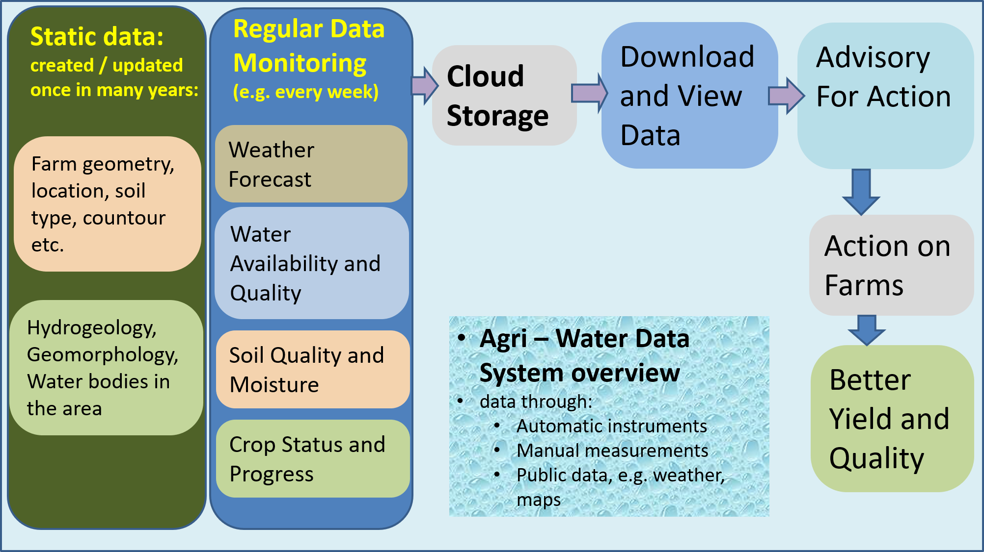
Smart agriculture aims at increasing crop yield and quality, with efficient use of inputs through data based decision at farm level. The data collection will include:
One time or infrequently varying data:
- Topography, aquifer, hydrogeology, geomorphology
- Water sources in the vicinity, in village, in taluka,
- Soil type
Regularly and frequent collected data collected throughout the cropping season, from pre-sowing to harvest, for:
- Local weather conditions and forecast,
- Soil quality and moisture,
- Water availability from all sources, and
- Crop growth status
The data may include that collected through automatic or manual measurements as well as publicly sourced data. The data is uploaded to an integrated system and stored, for viewing and analysis by experts as well as farmers or local agriculture extension workers or others. This enables expert advisory to farmers, at farm level as well as village level, and helps them make decisions at all stages of the crop cycle, make optimum use of inputs including water and nutrients and maintain soil health. The system also involves providing training to farmers and local village based trained persons for using technology and incorporating data guided decisions with their traditional agriculture practices.
The system will accumulate data, from large number of farms, over a long period of time, to develop a data repository which will help to improve decisions over time. Data collection at localized scale will help to get a clear picture of field conditions; and such collection done at multitude of field points will enable to gather the regional scenario. And so the system will need data collection points at various scales, covering clusters of farms and spreading to villages, clusters of villages, talukas, districts and so on. This vast data, over time, will also help develop AI/ML (Artificial Intelligence / Machine Learning) based improvements to decision making.
The system will also enable long term decisions like cropping pattern changes for various cropping seasons, irrigation pattern, village water budgeting, and developing village water security strategy.
Smart agriculture – Input-Process-Output Framework:
The following framework provides another view of a smart agriculture project and guides its various components.
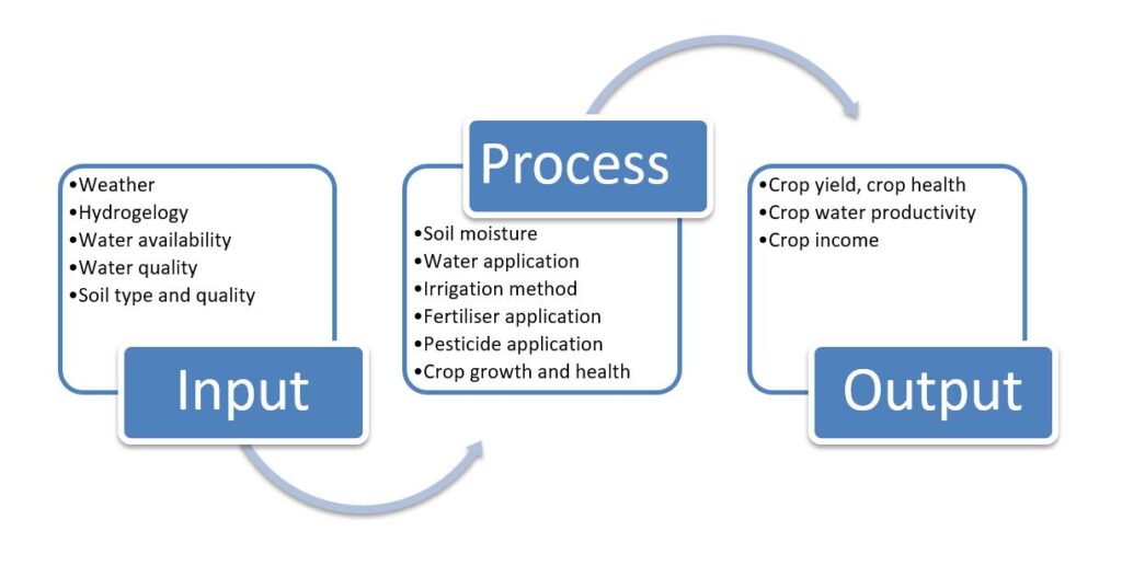
As illustrated above, this consists of input and process parameters which in turn affect the output parameters, as well as maintenance of health of basic input parameters, like water sources and soil health. The parameters include those from atmosphere – surface – subsurface areas, as illustrated in a diagram below:
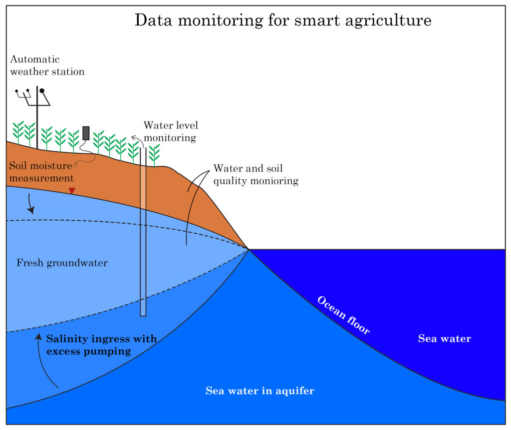
Such a monitoring system as seen in the diagram will include measuring different parameters for water, soil, atmosphere and crop growth, either digitally or manually. Some of these monitored parameters Include:
Monitored parameters:
Weather:
- From locally installed automatic weather stations (AWS), monitoring weather parameters such as rainfall, humidity, temperature, UV index unit, wind direction and wind speed.
- Through public weather data from agencies like IMD, Skymet, for the region/taluka etc
.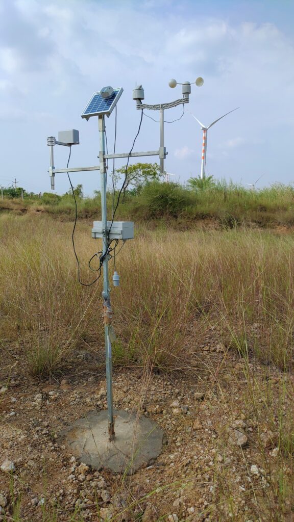 Automatic weather station
Water Availability:
- Surface water:
- water levels in village water bodies, availability of canal / river water, if any
- Groundwater level:
- through automatic electronic water level sensors
- though manual measurements
Water Use
flow meter: (if available) to estimate of volume of water used for irrigation.
Water quality:
Through on field water quality testing kit to test parameters like Arsenic, Fluoride, Nitrate, Total Iron, Sulphate, Chloride, pH, EC and TDS can be used.
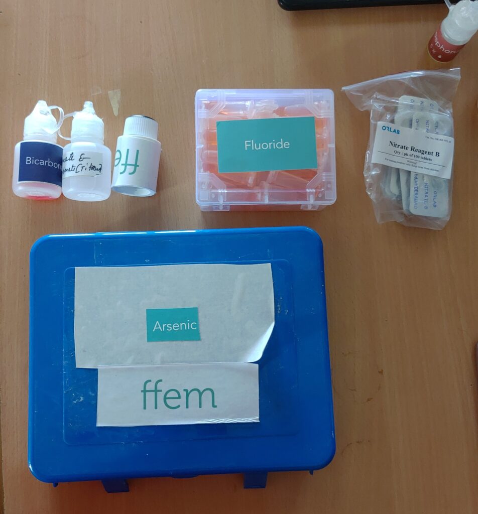
Soil and water quality testing kit
Soil
- Quality: through the field testing kits for soil test parameters like Organic Carbon, Nitrogen, Phosphorous, Potassium and pH is used.
- Soil moisture: through the soil moisture meters (portable or fixed) for monitoring moisture levels at various points within the field.
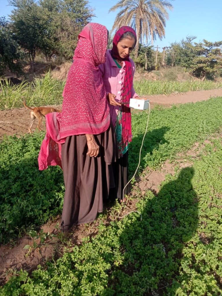
Community Resource persons measuring soil moisture through portable meters
If interested:
WIN Foundation and its partner organizations are implementing this system in selected villages, in Kutch and Dwarka districts. If you are interested, contact us at: info@winfoundations.org.
Abbreviations:
AWS Automatic Weather Station
pH Potential of Hydrogen
TDS Total dissolved Solids
EC Electrical Conductivity
UV Ultra Violet